The Project Gutenberg EBook of Fort Concho, by J. N. Gregory

This eBook is for the use of anyone anywhere in the United States and most
other parts of the world at no cost and with almost no restrictions
whatsoever.  You may copy it, give it away or re-use it under the terms of
the Project Gutenberg License included with this eBook or online at
www.gutenberg.org.  If you are not located in the United States, you'll have
to check the laws of the country where you are located before using this ebook.

Title: Fort Concho
       Its Why and Wherefore

Author: J. N. Gregory

Release Date: April 7, 2017 [EBook #54497]

Language: English

Character set encoding: UTF-8

*** START OF THIS PROJECT GUTENBERG EBOOK FORT CONCHO ***


Produced by Stephen Hutcheson and the Online Distributed
Proofreading Team at http://www.pgdp.net
FORT CONCHO MUSEUM
San Angelo, Texas
A people who take no pride in the noble achievements of remote ancestry will never achieve anything worthy to be remembered with pride by remote descendants.—Macaulay
The Department of the Interior on October 7, 1961 designated this Fort as a National Historic Landmark.

Fort Concho
1867-1889
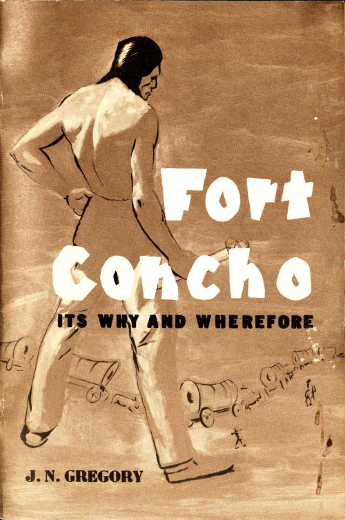
J. N. Gregory
Cover by A. J. Redd
First Printing 1957
Second Printing 1962
Third Printing 1970
NEWSFOTO YEARBOOKS
San Angelo, Texas
Dedicated
to the pioneer
men and women
of our Southwest.
Many people who visit the Fort Concho Museum and look over the parade ground and buildings of old Fort Concho, naturally ask the question, “Why did the United States Government build a fort in this place, and what did the fort accomplish?”
The object of this pamphlet is to answer that question, and to present the answer to the inquiring visitor at as small a cost as the printer makes possible.
Two maps of Texas will be found in the envelope at the back of the pamphlet. The smaller is a reproduction of one published in 1856, not too accurate from a geographic standpoint, but as accurate as the knowledge of the times allowed. The other map, accurate from the geographic point of view, endeavors to show the locations of some thirty-four forts and camps that were established and built by our War Department on the Texas Frontier during the Indian days.
The treaty of Guadalupe Hidalgo that brought to a close the war between the United States and Mexico, February 2, 1848, and the subsequent Gadsden Purchase of 1853, set the plan for the present boundaries between the two countries. A vast area of plains, deserts and mountains, an unmapped and untraveled wilderness was now owned by the Northern Republic. It was inhabited mostly by Comanche, Apache, Kiowa and other warlike Indian tribes, and it stretched from the settlements of South and East Texas, and from the lower Missouri River area to the new American settlements on the Pacific Coast.
Great events were in the making when in California in 1848, gold nuggets were found in the tailrace of Sutter’s Mill. The word passed around quickly, and the first modern international gold rush was on. It put the first sizeable amounts of precious metals into the coffers of the nations of the world since the Spanish Conquistadores ransacked the treasure houses of Peru and Mexico. It brought about modern mining practices, and before the end of the century, the search for gold was so international and intense that comparable strikes had been made in South Africa, Australia, Canada and Alaska, resulting in fresh redistribution of populations, not only in the United States but also in other portions of the world. The problems accompanying such redistribution were plentiful, and they are still plaguing us to this day.
But the lure that led men to our West was not gold alone. The El Dorado of man’s dreams, be it a gold vein, oil patch, store on Main Street, cattle ranch, or farm in Peaceful Valley, can very well lie in any new and unexplored lands. So it was then. Few men could afford for themselves, families and belongings the cost of passage by sailing ship, around the Horn or by portage at the Isthmus of Panama, from Boston, New York, Charleston, New Orleans, Galveston or Indianola, to San Francisco. Besides that, a fellow who was bent on making a trip liked to look over the country lying between home and his proposed destination. So, many found their El Dorado, not on the Pacific Coast but along the trails between the Great River and the Pacific Ocean.
The inhabitants of the crowded East and the folks of the 8 South felt their race-old urge to get on the move towards more freedom and opportunity. Old windy Horace Greeley was soon to advise, “Go West, Young Man.” So go West they did, young and old, first by small companies on horseback or in buckboards, then later by trains of covered wagons which carried their families and all earthly possessions, grouped together for companionship as well as for protection against the Indians.
Population movements in the United States have generally gone from East to West in parallel lines, once the Atlantic seaboard was settled. And so this great gold movement from East to West brought settlement of the intermediate lands between the Mississippi River and the Pacific Ocean by the natural contrasting types of North-South peoples.
The great Oregon and Santa Fe Trails serviced the people of the more northerly parts of our country, but for those in the southern parts a newer trail had to be found and by simple geography it had to cross Texas. You could enter the State from the sea at Galveston, Indianola or Corpus Christi, or by way of the land through Fort Smith in Arkansas, thence across the Indian Territory to the Red River; or directly from Louisiana through the fairly well settled and organized counties of East Texas. But no matter how you entered, there was only one way to get out, and so all trails converged on the Paso del Norte (present El Paso). To get out of Texas south of El Paso would land you in Mexico. To get out north of El Paso would take you across the Llano Estacado which in those days was considered a vast treeless plain, unbroken by any topographic changes, and completely devoid of water holes.
The accompanying map, published in 1856 in Yoakum’s History of Texas, shows clearly the political subdivisions and settlements of Texas in those times. A substantial part of the State, from the Panhandle to the upper Rio Grande, appears to be completely uninhabited and, therefore, politically unorganized. In a vague manner, this vast area might be assumed to be an unannexed portion of the counties of Bexar, El Paso, Presidio and Travis. This map does not speak approvingly of the Llano Estacado. Staked Plains, some called it.
From 1848 on to the recent past, various trail drivers, army officers and railroaders laid out trails from the settled parts of Texas to the Paso del Norte, always taking advantage of springs and water holes and avoiding the Llano Estacado and the great limestone canyons of the Rio Grande and its tributaries. That is, all did but the builders of the Southern Pacific Railroad. They came later, but yet too early to have the know-how of an Arthur Edward Stilwell. But that is another story.
A North-South trade route had existed for some two hundred years connecting Spanish Santa Fe, far north toward the headwaters 9 of the Rio Grande, south through the Paso del Norte to the settlements in the mother country of Mexico. The Santa Fe Trail extended to California, would cross this trade route at Santa Fe, well up in the Rocky Mountains, while the route through Texas would cross it at El Paso. And so these two places became the supply dumps where the great wagon trains took on horses, mules, beef and other supplies that would see them across the final leg of the journey west. It was a great opportunity for traders who had the supplies to sell, and the procuring middle man, the one who contacted both producer and merchant, was a man with great savvy and ability known as the Comanche Indian.
The Comanche despised walking; it was not adaptable to his method of making a living. He was a plains Indian, and somewhere back in the sixteenth or seventeenth century had somehow accumulated his first mustangs from offsprings of those horses lost by the Conquistadores from Spain. Prior to the arrival of the Spaniards in America, there were no horses, as we recognize them now, on either of the American continents. Now the Comanche as a mounted man probably roamed the great plains from present Wyoming to Durango, Mexico. It was easy to make a living on such a range. It abounded in buffalo; and the wise Comanche knew all the water holes. He drove the wily Apaches to the south until they crossed the Rio Grande and settled in a quasi-peaceful manner in Mexico, or later chose Arizona and New Mexico and preyed on the settlers, immigrants and prospectors.
From the records, the Comanche does not appear to have been a breeder of horses, cattle or sheep. But as a procurer of such livestock, he had no peer. Many years before Lewis and Clark were sent to evaluate the Northwestern part of the Louisiana Purchase lands that Mr. Jefferson had bought from Napoleon Bonaparte in 1803, the Comanche had learned to find his greatest pleasure and profit during his daring raids into the settlements of Mexico, raiding in great force as far south as the cities of Chihuahua and Durango.
The emotional inspiration for such forays on peaceful people was regarded as pure cussedness, but a more profound study shows that the trophies of such raids, excepting the scalps taken, were horses, cattle, sheep and slaves. Many of the stolen horses were for the Comanche’s personal use, because it took many animals to make the great raid during the Mexican Moon. The balance of the trophies was used for barter.
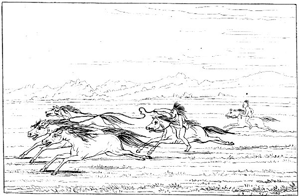

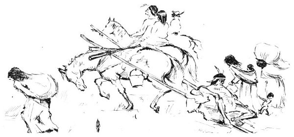
G. Catlin
Comanches Capturing Wild Horses
From “The North American Indians,” Vol. II, by George Catlin, London, 1841. The place: the Red River; the time: 1834.
Years before the purchase of 1803, he was trading his stolen stock, and possibly his slaves, to the French traders from the Spanish-French border near old Natchitoches (pronounced Nacotish) on the lower Red River. Or in later times, upon return from a successful raid, he roared out of Mexico and across the Rio Grande into Texas south of the Chisos Mountains. If short of war paint, he replenished his favorite red color from the outcroppings of cinnebar near Terlingua Creek, then headed through the badlands and out upon the range country by way of Persimmon Gap. From the Gap, he went to Comanche Springs (present Fort Stockton), crossed the Pecos River at Horsehead Crossing, then rode north to the Sand Dunes to water a famishing flock, after which he headed east to the Sulphur and the Big Spring. Then he turned northward around the Cap Rock that marks the eastern extremity of the terrible Llano Estacado, to proceed on north till he actually scrambled out upon that plateau. Then he proceeded towards Santa Fe to meet somewhere, possibly at Casas Amarillas, in that then desolate region, the Comancheros, or middle men between himself and the Mexican settlers of the upper Rio Grande Valley near Santa Fe.[1] He traded his trophies to the Comancheros for guns, ammunition or other less practical adjuncts that might suit his fancy of the moment. His Mexican Moon was then over and he returned to his portable village which he had left in some watered canyon that cut down eastward from the Llano Estacado.
The route as followed by these Indians was a well marked trail, and during the time of our westward migrations, it was well known and appears on the maps of the times. Another route into Mexico broke off the Western Trail at the Big Spring and ran down the valley of the North Concho River, across the Edwards Plateau, then through the passes of the Balcones Escarpment to cross the Rio Grande into Mexico near the present city of Eagle Pass. Mr. Evetts Haley refers to these trails as the Great Comanche War Trail, and gives a wonderful description of the activity on them in his recent book, Fort Concho and the Texas Frontier. An old map from the Army files in the National Archives calls the western branch the Grand Comanche War Trail. But call the trails what you may, they were still a stiff pain in the neck to anyone crossing them, and for the wagon trains and cattle herds going west, crossing was inevitable.
The greater raids into Mexico appear to have occurred rather regularly in September when the weather was most favorable, and the chief objectives could be struck during the light of a full moon. Thus, to the unhappy but fully expectant Mexicans, the September full moon was known as the Comanche Moon. At this time Mars, 12 the red God of War, hangs low and molten in the late summer night’s sky and reflects a light that is as red as the sand and clay soils of the Indian Territory.
Another favorite trick of these versatile middle men was to raid the settlements down the Rio Grande Valley south from Santa Fe and drive off the stock to a rendezvous with the Comancheros, who in turn traded them to unknowing Mexican settlers at other points on the river. During such raids it was deemed ethical but unprofitable to kill the settlers, since without them there would be no stock to drive off in a later raid. Besides, these Mexican settlers did not seriously molest the buffalo.
Such business sagacity however, did not apply in later times to the Republic of Texas, where each succeeding year saw new settlers break ground and homestead farther up the river valleys, whose streams had their origins in the motherland plains of the Comanche and Kiowa.
After its establishment in 1836, the infant republic found itself fighting a hot war on two fronts. The settlers near the Rio Grande, from Del Rio to the mouth of that river near Brownsville, suffered from raids out of Mexico by both Mexicans and Indians, while the northern prongs of the new settlements were exposed to the Comanches and Kiowas. It was a bitter struggle, fought generally in small isolated settlements where the determined Anglo-Saxon fought for his new home against an equally determined Indian fighting to preserve his ancient homeland and range. A Saxon’s scalp decorating a Comanche’s war shield might be avenged by an Indian’s entire skin decorating a rude barn door.
Matters were better controlled after the annexation of Texas by the United States and after the close of the Mexican War. But it took manpower and supplies to do it, something the new republic had been slow in acquiring. The treaty of Guadalupe Hidalgo provided, among other things, that the United States would make every effort to keep the Indians from raiding into Mexico; so in about 1849, the United States Army, mostly cavalry and mounted infantrymen (Dragoons), moved into Texas. They proceeded to establish a string of forts and camps from previously established Brown near the mouth of the Rio Grande to Duncan near Eagle Pass. For the upper Rio Grande in Texas, they set up what was later to be Fort Bliss (El Paso). As a northern line of defense for the settlers, they established, starting with Fort Duncan, the forts of Lincoln (D’Hanis), Martin Scott (Fredericksburg), Croghan (Burnet), Gates (Gatesville), Graham (Hillsboro) and Worth (Fort Worth). Only a few of the forts were ever protected by stockades. The war was one of movement. The places were supposed to be strategically located and manned by several companies of cavalry and some infantry; places from where punitive expeditions 13 could set out, establish supply bases, then try to run down the Indian raiders.
The standing army of the United States during the 1850’s was numbered at about fifteen thousand men and the personnel of the Texas forts accounted for about from one-fifth to one-third of that number. Many of the officers and men were veterans of the Mexican War, the forts usually being named in honor of American soldiers who lost their lives in that war. Many Civil War leaders, both Confederate and Union, received much field training from 1849 to the outbreak of that war in 1861, building and manning the forts, chasing, but seldom catching, the Indians, guarding the wagon trains and mail bags and exploring the wilderness for better trails and water holes.
There is a record, one of many left by the famous Captain Jack Hays of the Texas Rangers. It tells how he was hired by certain merchants of San Antonio who were anxious to trade with the merchants of Chihuahua, Mexico. His assignment was to find in 1848, a route from San Antonio to privately owned Fort Leaton where the Conchos River of Mexico meets the Rio Grande, and from which point to Chihuahua the going would be reasonably good. Hays and his mounted company of frontiersmen managed to make it to Leaton and back to San Antonio, but they found the going so rough that the journey took them three and one-half months. (Present Southern Pacific Railway west to Alpine). There were too many deep canyons along the tributaries of the Rio Grande.
The decade following 1849 was most active. The army detachments under capable officers explored to find routes from East Texas and from San Antonio to El Paso. But the wagon trains did not wait for their findings; they often made their own way and did their well-known creditable job. Mr. Jefferson Davis, Secretary of War, and himself a distinguished veteran of the Mexican War, did about all in his power to aid the new state of Texas, the Mexican settlements and the immigrant trains. He made treaties with the Indians and arranged reservations for them. This latter deal was not too successful. Friendly East Texas Indians almost starved on the reservations, and the more warlike plains tribes had no idea of staying there even when they agreed to move in. The old men’s tales of conquest and horse stealing were more than the young bucks could take.
Mr. Davis built new forts and, recognizing the great problems of communications that existed between such far flung positions, sought to remedy those by importing in 1856, through the seaport of Indianola, camels and their Arabian drivers.

G. Catlin
Comanche Village
From “The North American Indians,” Vol. II. by George Catlin, London 1841. Picture by Catlin, 1834, escorted by General
Henry Leavenworth and regiment of U.S. Dragoons.
The camels were concentrated at Camp Verde in Southern Kerr County, and breeding and testing immediately proceeded at a good pace. Tests for their strength and endurance carried the caravans across the Continental Divide and back, and the results were very gratifying. The Civil War put an end to the experiments. The last camel herd, before final sellouts to the carnivals, was privately owned near Austin in the early 1880’s.
By the time the Civil War broke out in 1861, the War Department had finally followed the advice of such able soldiers as Joe Johnston and Chase Whiting. The forts received a new alignment and were manned mostly by cavalry. Supplies were sent in as before, from bases like San Antonio. The wagons, pulled by oxen or mules, were well guarded in most instances by soldiers. The contracts for furnishing the supplies and their transportation were let to civilians.
The new alignment caused the abandonment of some interior forts and camps. The line on the lower Rio Grande was extended up the river by building Fort Hudson near the Devil’s River, about thirty miles north of San Felipe. Out in far Western Texas, they built Fort Quitman, down the river from El Paso.
Several things were done to discourage the Comanche and Kiowa whose depredations along the Grand War Trail had been greatly stepped up. The War Department flanked the trail on the west by the building of a sizeable establishment in a beautiful and romantic spot in the Davis Mountains and named it Fort Davis in honor of the secretary. Near this spot, more than three hundred years before, had passed the shipwrecked, unhorsed and enslaved, but still valiant Spaniard, Cabeza de Vaca. He would later write, in his report to his Viceroy describing his journey after leaving the great arid plains to the north, of a valley through which flowed “limpid waters.”[2]
After Fort Davis, the Department unveiled Fort Lancaster (western Crockett County) as a flanker to the east of the trail. It was cozily situated in the mesas not far from the Pecos River and beside Live Oak Creek that flows delightful spring water.
Then the War Department built Fort Stockton (Pecos County), smack in the middle of the Grand Trail and right beside the best spring of water on its entire route.
Now to further protect immigrants and mail bags on the route west and to protect settlers of central and northern Texas who were still moving higher up the river valleys, it set up Fort Chadbourne as a pivot between the new western line and the new lower Rio Grande Valley line. From Fort Chadbourne on northeasterly to the Indian Territory were Forts Phantom Hill (Abilene) and Belknap (New Castle). But Chadbourne was a near miss, because it was not well located and its water supply was not adequate. 16 However, not until the Civil War was over was it finally abandoned in 1867 and a new site chosen for its replacement at the confluence of the North, South and Middle Concho Rivers. This new position would be called Fort Concho, and here eventually would be built the city of San Angelo.
As the decade preceding the outbreak of the Civil War was closing, the great wagon trails from San Antonio and East Texas to El Paso must have been a sight to behold. Most of them converged on Castle Gap and the Horsehead Crossing of the Pecos River, from where they had a choice of two routes to El Paso. The California Overland Mail (Butterfield Overland Mail), 2,795 miles from St. Louis to San Francisco, entered Texas by way of Fort Smith, Arkansas, followed the line of forts southwesterly to the middle Concho River then turned westerly up that valley, then through Castle Gap to Horsehead Crossing. From here the early route followed up the Pecos River to Pope’s Crossing near the present Red Bluff Reservoir, thence westward to El Paso, by way of Delaware Creek and the Hueco Tanks. A more southerly route from Horsehead Crossing was probably a better choice. It went from the Crossing direct to Fort Stockton, Leon Springs, Toyahvale, Fort Davis, thence to Van Horn’s well and El Paso. It also had the advantage of servicing the westerly line of forts.
The original run over this new mail trail to California was made in 1858 and the New York Herald sent a special news correspondent, one W. L. Ormsby, to be a through passenger on the mule-drawn coach so that he could report the trip. The poor fellow was only twenty-three years old, but age being in his favor, he lived through it all. His description of the trail from between the upper water holes of the Middle Concho River (near present Stiles) to Castle Gap and the Horsehead Crossing is most illuminating.
“Strewn along the load, and far as the eye could reach along the plain—decayed and decaying animals, the bones of cattle and sometimes of men (the hide drying on the skin in the arid atmosphere), all told a fearful story of anguish and terrific death from the pangs of thirst. For miles and miles these bones strew the plain....”
It appears from this on the spot observation, that the trails across level plains country were very wide. The wagon trains did not move in single file. That would expose them too much to Indian attacks, and besides, the longer the line, the worse the dust. The old wagon wheel ruts, still noticeable to this day along the route described above by Ormsby, cover a wide area on the plains east of Castle Gap, before they converge at that narrow pass. These can be seen west of the China Ponds where they move westerly about three miles south of the land grants known as the alphabet blocks, given later by the State of Texas to the Corpus Christi, San 17 Diego and Rio Grande Narrow Gauge Rail Road. (Try painting that one on a narrow gauge box car!)
During 1858 and 1859, Captain Earl Van Dorn, soon to be a member of the Confederate High Command, vigorously carried the war to the Indians and pushed them north, back across the Red River. They didn’t remain there long. Texas seceded from the Union in 1861 and the Federal soldiers marched out of the forts and left them to the Confederate forces. Again the proper manpower was lacking. Some forts were abandoned so as to shorten the defense line and some of these, as at Lancaster, were burned by the Indians. The Indians, now spurred on by Union agents, carried on a still more bloody and aggressive warfare on the Texas frontier. Confederates, and Ranger Companies, coupled with frontiersmen reacted promptly and vigorously, but it was a long line of defense from the Red River to the Rio Grande. Defend it they did, against the Indians, and against lawless elements such as deserters and others renegades, hostile Union sympathizers and border ruffians from without the state.
The Negro slave was emancipated by proclamation in Texas on June 19, 1865 (June’teenth), about two months after General Lee surrendered the Army of Northern Virginia at Appomattox Court House.[3] The last land battle of the Civil War was fought on May 13, 1865, in Cameron County, Texas when invading Federal forces were routed near Brownsville. That engagement is known as the Battle of Palmito Ranch.
From the end of the war until 1867, the frontier settlements had no organized military forces to protect them from the Indians, and it was against the law for Texans to carry guns. Added to this were the turmoils of Reconstruction which were about as bitter in the populated parts of the state as they were in other parts of the South.
The occupying United States Army under General Phil Sheridan was now mostly recruited from among the Negroes, and the army was not used against the Indians until 1867, when orders went out to get busy and put the forts and camps in order.[4] General Sheridan’s name was about as popular in Virginia and Texas as General W. T. Sherman’s was in Georgia and Mississippi.

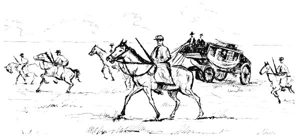
Action West of Horsehead Crossing.
(Castle Gap is at the upper left.)
But both Sherman and Sheridan came to Texas, and Sherman, after narrowly escaping the loss of his scalp on the Texas frontier, finally realized the necessity of a last organized military effort to either rid the country of the Indians or give it back to them. That was in 1871. However, in 1869, a new alignment of the forts had been seen as necessary. Never again reoccupied were certain of the interior ones such as Worth, Graham, Gates, Croghan, Martin Scott, Lincoln, Chadbourne and Ewell (La Salle County). Fort Belknap, on the Salt Fork of the Brazos River in Young County, had been the largest military post in North Texas prior to the Civil War. In 1867, the 6th Cavalry was ordered to prepare it for reoccupation. They worked for five months, but then this fort was ordered evacuated and its place was taken by a new one, Fort Griffin, some thirty-seven miles up the Clear Fork of the Brazos from Belknap.
Now to extend the northeasterly trending line of forts closer to the Indian Territory, the Army built Fort Richardson near the present town of Jacksboro.
The site chosen as the replacement for Fort Chadbourne, to be called Fort Concho, was at the confluence of the North Concho River with the combined waters of the Middle Concho, Spring Creek, Dove Creek and the South Concho, the last three named streams being fed by bountiful springs. This abundance of water and the geographically central location marked the spot as the natural convergence of trails from East, Northeast and South Texas before they headed westward for Horsehead Crossing and El Paso. Nature had been kind to this oasis in an otherwise desolate region. The fishing was extremely good and the clear waters of the streams supported mussels, the variety that produces gem pearls, hence the Spanish name of Concho. Herds of buffalo grazed within sight of the new fort. Quail and turkey were plentiful.
These three new positions, Concho, Griffin and Richardson, located on a line 220 miles long, as yet unconnected by either telegraph or rail, would soon be the centers of men, supplies and animals for the campaigns that finally broke the concerted powers of the Indians. These campaigns carried the soldiers from the Indian Territory and the New Mexico Territory on the North, to the actual interior of Old Mexico on the South.
From the times in 1866 and 1867 when Richardson and Concho were ordered built until 1871, the troops undertook no organized campaigns against the Indians. The settlers suffered constantly and the Indians learned new tricks. Many more learned how to live off government bounty on the reservations in Indian Territory, then hit the war path along with their wild brethren from the Texas Panhandle. They were amply protected on their return to the reservations by the Indian agents in charge, who believed their wards could do no wrong. Why, they would ask, would an Indian steal cattle when he had all the buffalo meat he wanted?
A cavalry expedition out of Fort Concho working the edges of the Llano Estacado in 1872, captured a Comanchero who told how 20 he and his companions traded the Indian arms, ammunition and supplies for cattle, horses and sheep that they had stolen during their raids. He even showed the soldiers the well worn trails across the Llano Estacado towards Santa Fe and the valley of the Rio Grande. Thus the secret was finally revealed to the Army. It seems unbelievable at this time that such ignorance could prevail over the cries and protests of the Texas ranchmen who were losing cattle by the tens of thousands.[5] But such was the case, and in 1867, the Comanches even stole horses from the post herd at Fort Concho. We must remember that in that same year the mild policies of President Andrew Johnson in Washington were overruled by the radicals in the United States Congress, and the bitter years of reconstruction followed for the Southern States. All former Confederate soldiers were deprived of the vote, and radicals, carpetbaggers, scalawags from the South and freed Negroes ruled the State. The Army was used, not to fight Indians, but to guard the new social system.
The prospect appeared brighter for the settlers when in the Fall of 1869, one hundred soldiers from Fort Concho managed to engage an Indian force on the Salt Fork of the Brazos River. It was a drawn fight, but immediately thereafter a larger force from the same fort engaged and defeated the Indians in the same area. Texans were cheered by the news of this new tone of aggressiveness shown by the Army. It was the only way. The war had to be carried to the Indians the same way Earl Van Dorn had carried the fight to them on the eve of the Civil War.
But the time for real action had not arrived even as late as 1869. On February 18, 1870, a citizen was killed and scalped within one-quarter of a mile of the post limits at Fort Concho. In January of the same year, eighteen mules were stolen from the Q.M. corral at that same post. The same year, 1870, while Colonel Grierson was building Fort Sill in the Indian Territory, Chief Kicking Bird, a Kiowa, defeated the Command of Captain C. B. McClellan near the present town of Seymour. As late as March of 1872, a wagon train was waylaid near Grierson Springs in Reagan 21 County and the teamsters killed by the Indians. Two companies of the 9th Cavalry came upon the scene by accident, engaged the Indians but withdrew before a decision was reached.[6]
The lamentations of the border people were finally heard in Washington and in April, 1871, General W. T. Sherman came to San Antonio. The next month, accompanied by General Randolph B. Marcy and an escort of seventeen men, he left for an inspection of the frontier. General Marcy was the same officer (then, Captain Marcy) who, in 1849 and later, had played such an important part in exploring and reporting to Congress on trails through Texas. The great explorer was still an outdoor man of action.
The little expedition proceeded by way of Boerne, Fredericksburg, the old Spanish Fort on the San Saba which had withstood a great Comanche Indian siege in 1758, Fort McKavett, Kickapoo Springs and Fort Concho. From Fort Concho it followed the military trail on northeasterly by the remains of Fort Chadbourne and Phantom Hill and on towards Belknap.
General Marcy’s journal is of great interest. He relates:
“We crossed immense herds of cattle today, which are allowed to run wild upon the prairies, and they multiply very rapidly. The only attention the owners give them is to brand the calves and occasionally go out to see where they range. The remains of several ranches were observed, the occupants of which have either been 22 killed or driven off to the more dense settlements, by the Indians. Indeed, this rich and beautiful section does not contain, today (May 17, 1871), as many white people as it did when I visited it eighteen years ago, and if the Indian marauders are not punished, the whole country seems to be in a fair way of being totally depopulated.” He continues:
“May 18th, 1871—This morning five teamsters, who, with seven others, had been with a mule wagon train en route to Fort Griffin (Captain Henry Warren’s) with corn for the post, were attacked on the open prairie, about ten miles east of Salt Creek, by 100 Indians, and seven of the teamsters were killed and one wounded. General Sherman immediately ordered Colonel Mackenzie to take a force of 150 cavalry, with thirty days’ rations on pack mules, and pursue and chastise the marauders.”
An interesting angle to this affair was that Sherman’s party had been observed by the same Indians who murdered the teamsters, but were unmolested by them because they were waiting for the wagon train which they considered nearer top priority. Sherman realized later that he had nearly lost his scalp.[7]
This Colonel Mackenzie had reported in at Fort Concho as commanding officer on September 6, 1869. Born in New York, July 27, 1840, and christened RANALD SLIDELL, he had graduated first in his class at West Point in 1862. He served in the Union Army during the Civil War, received several wounds in action, and was a brigadier general when that war closed. The remainder of his professional life was devoted to active high command in the Indian wars. At various times he served at Forts Brown, Clark, McKavett, Concho and Richardson, engaging in his last Indian fight at Willow Creek, Wyoming in 1876. He was retired from the Army for disability in 1884 and died a bachelor at New Brighton, New York in 1889.
Along with Mackenzie, Colonel William Rufus Shafter who arrived to command at Fort Concho in January, 1870, the War Department had its two best young officers serving in the West Texas theatre.
Shafter had no West Point training. Born in Michigan on October 16, 1835, he entered the Union Army in the Civil War as a first lieutenant and by the end of that war had been breveted brigadier general of volunteers. He was later awarded The Congressional Medal of Honor for service during that war. He was commissioned lieutenant colonel of regulars in 1869 and first saw service in West Texas with the 24th Infantry at Fort McKavett. Later in life he was to command the American armies in Cuba during the Spanish American War.
During the summer of 1871, while commanding forces at Fort Davis, he set out with cavalry from both Forts Davis and Stockton and pursued a large raiding party of Indians from the Fort Davis area northeasterly until the trail moved into the great sand dune country near where the city of Monahans now stands. He spent fourteen days in this pursuit but as was usual in such matters, could never force an engagement. However, he learned that the heretofore dreaded sand dunes contained fresh water a few feet below the surface in several places, and that the area was a great refuge for Indians and was one of those rendezvous where horse-and-cattle stealing Indians met the Comanchero traders from New Mexico.
The command at Fort Concho, as at the other forts, rotated in a perpetual manner. After service elsewhere, Mackenzie returned to Concho to organize five companies of the 4th Cavalry and a headquarters company for service at Fort Richardson, nearer the Indian Territory. His column moved out March 27, 1871, cavalry, pack mules and wagons. The bachelor commander even allowed wives of the men to accompany the expedition as far as the new headquarters at Fort Richardson.
The weather was crisp and cold as they forded the North Concho and soon passed Mt. Margaret, named after “the most accomplished, loving and devoted wife of one of our favorite captains, E. B. Beaumont”—(Beaumont-Beautiful Mountain), so wrote Captain Robert G. Carter, historian and winner of The Congressional Medal of Honor in the Indian Wars, who was a member of the expedition. (Mt. Margaret is the outstanding hill at Tennison.) They pitched camp the first night at old Fort Chadbourne, from where they followed the military trail passing en route huge herds of buffalo, as they went on by old Forts Phantom Hill, Belknap and on into Richardson.
Two months later, in May, Colonel Mackenzie roused his 4th Cavalry at Fort Richardson and set out to obey General Sherman’s orders issued after the killing of the teamsters at Salt Creek. But it began to rain. After a futile chase Colonel Mackenzie headed for Fort Sill, commanded by Colonel Benjamin H. Grierson. There he learned that Sherman had left but not before the Chiefs Satank (Sitting Bear), Big Tree and Satanta (White Bear) had returned to the reservation at Sill and boasted of murdering the teamsters. Mackenzie arrested and escorted the three Indians to Jacksboro for trial in the Texas court. Satank purposely got himself killed by a guard on the march, but Satanta and Big Tree were later sentenced to prison in the state penitentiary at Huntsville. The duplicity of these reservation Indians should now have been apparent to even Grierson and the Indian lovers in Washington and Austin, but it was not.
A good insight into the Indian problem of the times, and of which we have a written record, appeared at the trial of the two Indian chiefs during July of 1871 in the little log courthouse on the public square of Jacksboro. Charles Soward was the presiding judge. Samuel W. T. Lanham, later to be a two term Governor of Texas, was the district attorney. The court appointed Thomas Fall and Joe Woolfork of the Weatherford Bar to represent the defendants.
Thomas Williams, the foreman of the Jury, was a frontier citizen and a brother of the Governor of Indiana.
The principal witnesses against the defendants were Colonel Mackenzie, Lawrie (or Lowerie) Tatum, the Indian Agent who had heard their statements at Fort Sill and Thomas Brazeal, the teamster who had escaped from the Salt Creek massacre.
Our Captain Carter wrote:
“Under a strong guard accompanied by his counsel and an interpreter, the Chief, clanking his chain, walked to the little log courthouse on the public square. The jury had been impaneled and the District Attorney bustled and flourished around. The whole country armed to the teeth crowded the courthouse and stood outside listening through the open windows. The Chief’s attorneys made a plea for him, and referred to the wrongs the red man had suffered. How he had been cheated and dispoiled of his lands and driven westward until it seemed there was no limit to the greed of the white man. They excused his crime as just retaliation for centuries of wrong. The jurors sat on long benches, each in his shirt sleeves and with shooting irons strapped to his hip.”
Satanta got up to defend himself before his accusers. Over six feet tall, the perfect figure of an athlete and well known as the orator of the plains who could sway councils of both whites and Indians, he could well have influenced the jury by mute silence, but instead he lied and dissembled to save his life. He never mentioned the wrongs done his people by the whites. Instead, speaking through the interpreter, he proceeded as follows:
... “I have never been so near the Tehannas (Texans) before. I look around me and see your braves, squaws and papooses, and I have said in my heart, if I ever get back to my people, I will never make war upon you. I have always been the friend of the white man, ever since I was so high (indicating by sign the height of a boy). My tribe have taunted me and called me a squaw because I have been the friend of the Tehannas. I am suffering now for the crimes of bad Indians—of Satank and Lone Wolf and Kicking Bird and Big Bow and Fast Bear and Eagle Heart, and if you will let me go, I will kill the three latter with my own hand....”
The evidence against the two Chiefs was debated by the jury 25 and both were sentenced to death. This sentence was later commuted to life imprisonment.
Now, a few statements from the court record as to what the District Attorney had to say point to some of the misunderstandings of the times when it came to the Indian problems on the western frontiers.
The following excerpts from his plea before the court show clearly, not only the feelings of the frontiersmen towards the uncontrolled Indians, but also the contempt in which they, both frontiersmen and Indians, held the people who by appeasement, crookedness and ignorance tried to manage the Indian affairs of the nation from a far away city:
“Satanta, the veteran council chief of the Kiowas—the orator—the diplomat—the counselor of his tribe—the pulse of his race; Big Tree, the young war chief, who leads in the thickest of the fight, and follows no one in the chase—the mighty warrior, with the speed of the deer and the eye of the eagle, are before this bar in the charge of the law! So they would be described by Indian admirers, who live in more secured and favored lands, remote from the frontier—where ‘distance lends enchantment’ to the imagination—where the story of Pocohantas and the speech of Logan, the Mingo, are read, and the dread sound of the warwhoop is not heard. We who see them today, disrobed of all their fancied graces exposed in the light of reality, behold them through far different lenses. We recognize in Satanta the arch fiend of treachery and blood, the cunning Cataline—the promoter of strife—the breaker of treaties signed by his own hand—the inciter of his fellows to rapine and murder, as well as the most canting and double-tongued hypocrite where detected and overcome! In Big Tree, we perceive the tiger-demon who tasted blood and loved it as his own food—who stops at no crime how black soever—who is swift at every species of ferocity and pities not at any sight of agony or death—he can scalp, burn, torture, mangle and deface his victims, with all the superlatives of cruelty, and have no feeling of sympathy or remorse. We look in vain to see, in them, anything to be admired or even endured. Powerful legislative influences have been brought to bear to procure for them annuities, reservations and supplies. Federal munificence has fostered and nourished them, fed and clothed them; from their strongholds of protection they have come down upon us ‘like wolves on the fold’; treaties have been solemnly made with them, wherein they have been considered with all the formalities of quasi nationalities; immense financial ‘rings’ have had their origin in, and draw their vitality from, the ‘Indian question’; unblushing corruption has stalked abroad, created and kept alive through
“‘—the poor Indian, whose untutored mind,
Sees God in clouds, or hears him in the wind.’
“... For many years, predatory and numerous bands of these ‘pets of the government’ have waged the most relentless and heart-rending warfare upon our frontier, stealing our property and killing our citizens. We have cried aloud for help.... It is a fact, well known in Texas, that stolen property has been traced to the very doors of the reservation and there identified by our people, to no purpose....”
Mackenzie realized those things and knew he could receive no cooperation from Grierson at Fort Sill, so in September, acting on orders, concentrated a force of eight companies of the 4th Cavalry, two companies of the 11th Infantry and thirty Tonkawa Indian scouts at old Camp Cooper near Fort Griffin. The infantry would be used to guard the supply bases as he moved northwesterly in the hope of engaging the wild brethren under Chief Quanah. He bivouaced in the mouth of Blanco Canyon and lost sixty odd horses to an Indian raid that night. The next day the command moved up the canyon and later came out on the flat prairie of the Llano Estacado. A large retreating body of Indians was sighted but a Norther blew up, and Mackenzie was forced back down the canyon by the cold weather. He withdrew to Fort Richardson where the command arrived in late November. He accomplished nothing and as for himself, he received an arrow wound during a small skirmish in the canyon.
With the coming of spring, things picked up. Mackenzie received orders in May to establish a camp of cavalry and infantry on the Fresh Fork of the Brazos, from which his cavalry should operate in pursuit of hostile Indians. He moved out of Fort Richardson in June while Shafter at Fort Concho organized wagon trains and supplies, these coming from as far away as Fort Brown. He was to meet Mackenzie near the mouth of Blanco Canyon, where the base was to be established. By September, 1872, Mackenzie and his cavalry had moved from Blanco Canyon to Fort Sumner (New Mexico), thence north to Fort Bascom (New Mexico), then southeasterly to Palo Duro Canyon and south to his base camp in Blanco Canyon. He had found no Indians or Comancheros, but he had followed well marked Comanchero trails across the Llano Estacado and had no trouble in finding water holes. The Staked Plains were not nearly so tough as the high army echelons had been led to believe.
Puzzled by the lack of Indians he set out for the headwaters of the Red River and on September 29, discovered a large camp on a tributary of the Red, northeast of Palo Duro. He immediately attacked with five companies of cavalry, routed the braves, burned 262 Indian lodges, and captured 127 women and children, and an estimated 3,000 head of horses. His own losses were light if we except the fact that the Indian braves returned that night and recovered 27 all of their horses by stampeding them. Mackenzie never forgot that midnight raid.
This drubbing had a salutary effect on the Indians. The captives were sent to Fort Concho for prisoner exchange, and many warriors sought safety on the reservations. Their Chief Satank was dead and Chiefs Satanta and Big Tree were in the penitentiary at Huntsville. The next spring the remaining one hundred captive women and children at Fort Concho were delivered back to the reservation at Fort Sill amid great rejoicing by the braves. They began to feel that the pale face was not such a bad hombre after all. Evetts Haley says that some of the braves so seriously considered settling down that they even sent their women into the fields to see what work was like.
Things now looked better and the Indian lovers persuaded Governor Edmund J. Davis to issue pardons to Satanta and Big Tree. This infuriated General Sherman. That was in April of 1873. Trouble immediately started again.
But meanwhile Mackenzie had returned to Fort Concho, where he arrived in January of that year, and set up the headquarters of the 4th Cavalry Regiment. Then in March, the 4th itself left Fort Richardson for Concho, and the 7th Cavalry took over at Richardson.[8] The 4th headed for Fort Concho, the same column, soldiers, wagons, wives and their household plunder that had moved north to Richardson two years before. General Sherman had decided to do something about that other Texas frontier, the Rio Grande, and he wanted Mackenzie with his 4th Cavalry to handle the job.
Things were not, and never had been, peaceful along the Rio Grande. It was another frontier with two parts. From Ringgold Barracks, opposite the Mexican city of Camargo, on down to the mouth of the Rio Grande, a man by the name of Juan Cortina, once a general in the Mexican Army that had opposed General Zachary Taylor’s invasion of Mexico, sought to make a living in the grand style. He was very successful as a bandit and became the “Robin Hood” of his side of the border. During the Civil War his banditry ceased. He became a trader and did well because the Rio Grande became the only outlet of the Southern Confederacy. But with the close of the war, he resumed his favorite role as a bandit and declared that the Nueces River and not the Rio Grande, was the border between his country and the United States.
The result was that he and other lesser bandits overran the entire 28 country from the Rio Grande to the Nueces, killed for the pleasure of killing and drove into Mexico tens of thousands of Texas cattle. In 1875, one of his raids came within seven miles of Corpus Christi. Truly, his activities were as fearsome and as costly as were those of the Indians on the other frontiers of the state. But the United States Army did little about it, being unable to catch raiders in Texas, and unwilling to attack them in Mexico. The Texas Rangers, recreated in 1874, began to effectually take care of the matter. Thirty-one of these men, under their able commander Captain Leander H. McNelly, began to take a bite out of these raiders in 1875, killing them not only in Texas but pursuing and attacking them in Mexico itself.
General Porfirio Diaz came to power in Mexico about this time and ended the Cortina troubles by arresting and confining that gentleman to the environs of Mexico City. The Rangers took care of the rest of the gangs.
Along the upper Rio Grande, the raids into Texas were made by Indians: the Kickapoos, Lipans and Apaches. These tribes had settled in that great arid and sparsely inhabited area that extends south of the Rio Grande from Laredo to El Paso. That part of Mexico was a no-man’s land. The small Mexican and Indian villages were a law unto themselves. The Mexicans often joined the Indians on their raids, and the cattle and horses brought back found a ready market in the Mexican villages.

G. Catlin
U. STATES’ INDIAN FRONTIER IN 1840.
Shewing the positions of the Tribes that have been removed west of the Mississippi.
By George Catlin.
The Lipans, like the Apaches, were natives of the Great Plains country. The Kickapoos were easterners, and had been termed “friendly Indians,” upon their arrival west of the Mississippi River. The term “friendly Indian” often used in writings and reports of the times referred in the larger sense to those tribes such as the Kickapoos, Cherokees, Choctaws, Chickasaws, Seminoles, Delawares and others that had once been powerful tribes in the eastern United States, but because of the encroachment of the white settlers, they had, by treaty, coercion or force during the early 1800’s, been continually moved by the United States Government from their ancestral or reservation lands in the East. They finally ended up at various times on reservations assigned them in what is now Kansas and Oklahoma (Indian Territory). Here they usually encountered hostility from the native tribes of the Great Plains whose superior numbers threatened their entire existence. They were considered intruders and were obliged to turn to the United States troops, where possible, for protection. Their natural ability as “trackers” made them a necessary unit in any force of troops that sought to engage hostile Indians.
The Seminoles from Florida were pretty well mixed with Negro blood upon their arrival in East Texas, and later in the Indian Territory. The reason for this was that prior to the Civil War many run-away Negro slaves had sought and found sanctuary among these Indians, living at that time in the fastnesses of the Everglades.
During the latter days of the Civil War, December of 1864, a company of frontier scouts out of Fort Belknap discovered a freshly abandoned Indian camp west of the ruins of old Fort Phantom Hill. The scouts estimated that perhaps 5,000 Indians had camped there.
During the preceding fall, Comanche and Kiowa Indians in large numbers had broken up the settlements on the northern frontier in Young County. Therefore, it was assumed, and assumed too hastily as it turned out, that these Indians had occupied the camp and were on the march to find a permanent spring and summer location from where they could further raid the settlements.
Actually these Indians were friendly Kickapoos from the Indian Territory, and as it turned out, they were probably peacefully moving themselves and their entire tribe to join a tiny remnant of the tribe that had, years before, settled in Old Mexico, some forty miles west of Laredo.
The hasty assumption that these Indians were hostile led to the Battle of Dove Creek fought on Sunday, the 8th of January, 1865. The scene of the battle was the Indian encampment on the south bank of Dove Creek about three miles above its confluence with Spring Creek, and fifteen miles southwest of the present Tom Green County court house.
After the discovery of the abandoned camp near Phantom Hill, the Indians were trailed by scouts. Confederate regulars had been concentrated at Camp Colorado, and militia had been moved from Erath, Brown, Comanche and Parker Counties.
These two columns of troops, numbering some 400 men, concentrated above the Indian encampment before daybreak. They attacked at daylight. It was an impetuous charge and was met by 31 deadly fire from the Enfield rifles of 600 braves, well protected by the underbrush of the creek bottom. The militia, respectfully referred to by the regulars as the “flop eared militia,” suffered heavily in their charge. They broke and fled and were of no more value in the field.
The regulars, now badly outnumbered and outflanked, were slowly forced back and withdrew towards Spring Creek, fighting from the shelters of the oak groves as they retired. This action continued all day, and they encamped that night with all their wounded and the reformed militia on Spring Creek, about eight miles from the original battle ground. They left twenty-two dead on the field and carried away about forty wounded.
The long retreat to the mouth of the Concho River started the next morning in a blinding snow storm that made pursuit by the Indians impossible. They resorted to captured Indian ponies as food supply.
It had been a most unfortunate affair. The Kickapoos crossed the Mexican border in the Eagle Pass area and settled down about forty miles inland. Always irked by memories of the unprovoked Dove Creek fight, they thereafter heartily joined future raids into Texas. They were no longer “friendly Indians.”
It was this matter of raids into Texas in the upper Rio Grande country that attracted General Sherman’s attention in March of 1873, when he ordered Colonel Mackenzie and his 4th Cavalry to Fort Concho. From Concho they moved to Fort Clark, only about thirty miles from the Mexican border. At Fort Clark a conference of high ranking officials was held, including apparently the Secretary of War, General Phil Sheridan, Mackenzie and others. No orders were issued but after the conference was over, the “brass” reviewed the 4th Cavalry. The “ten-year” men in the regiment knew that something big was brewing.
Dark and early, on the morning of May 17, 1873, Colonel Mackenzie led 400 men of his 4th Cavalry and twenty or thirty Seminole scouts under Lt. John L. Bullis, on a drive across the Rio Grande into Mexico.
After four days and night of continuous riding and fighting, the small expeditionary force, carrying their supplies in their pockets and with no time taken out for sleeping, recrossed the river and were back on friendly Texas soil. They had covered some 160 miles and had burned three Kickapoo and Lipan villages, killed a considerable number of braves, captured forty women and children, plus the chief of the Lipans, and had driven the remainder of the tribes into the Santa Rosa Mountains.
Washington and Mexico City both hit the ceiling over this invasion of a friendly nation. Mackenzie could show no written orders for the action. Had he failed, he would have been court-martialed, 32 and he knew that beforehand. But President Grant stood by his officer, and the incident soon blew over. In fact a year or two later most of the remaining Kickapoos were persuaded to accept Uncle Sam’s hospitality. They went from Mexico to Fort Sill, by way of Fort Concho, and were given a cozy place on a reservation in the Indian Territory.[9]
By this time it is apparent that our Colonel Mackenzie was the fair-haired boy of President Grant and Generals Sherman and Sheridan. During the Civil War, Grant had regarded him as his ablest young officer. Now if things got out of line, you would simply “dress on Bobs.”
Truly, things were about to get out of line again. Some foolish policy of appeasement was still rampant in Washington, so Satanta and Big Tree were released from the penitentiary. This combined with other factors, such as the restlessness of the Indians on the reservations, and the slaughter of the buffalo, united the efforts of the Comanche tribe. Along with the Kiowas, now aided by the Cheyennes, they started trouble all over again. Once more the raids, during the spring of 1874, hit the Texas frontier, and as usual the soldiers while sleeping, had their horses stolen. Buffalo hunters in their lonely camps on the Panhandle plains were murdered and scalped.
Just east of the old Adobe Walls ruins, on the north side of the Canadian River in what is now northeastern Hutchinson County, twenty-eight men and one woman fortified themselves in three new adobe buildings that had just been completed as a trading post in anticipation of the northern migration of the great buffalo herds.
They were awakened before daylight on the morning of June 27, 1874, by a sharp cracking noise. The newly cut cottonwood ridge pole that supported the roof on one of the three buildings had settled, and the sod-covered roof threatened to collapse at any moment. Fifteen men worked until daylight propping up the roof. That accident saved the lives of all at the Walls, for just as daylight came, being awake and outside, they saw to the eastward, an estimated 700 mounted Indians riding hard for the settlement. The attacking force was less than half a mile away when it deployed in a great converging arc.
Billy Dixon, the buffalo hunter and frontier scout described the charge in a dramatic manner:
“There was never a more splendidly barbaric sight. In after years I was glad that I had seen it. Hundreds of warriors, the flower of the fighting men of the Southwestern Plains tribes, mounted upon their finest horses, armed with guns and lances, and carrying heavy shields of thick buffalo hide, were coming like the wind. Over all was splashed the rich colors of red, vermilion and ochre, on the bodies of the men, on the bodies of the running horses. Scalps dangled from bridles, gorgeous war-bonnets fluttered their plumes, bright feathers dangled from the tails and manes of the horses, and the bronzed, half-naked bodies of the riders glittered with ornaments of silver and brass. Behind this head-long charging host stretched the Plains, on whose horizon the rising sun was lifting its morning fires. The warriors seemed to emerge from this glorious background.” (Life of Billy Dixon, by Olive K. Dixon, The Southwest Press, Dallas, Texas.)
The three buildings were about equally manned by the whites. Doors were closed and then barricaded, as were the windows and transoms, by sacks of flour and grain. The first charge was broken up at the very walls of the buildings by the lead from the big buffalo guns. Thanks to the thick abode walls and to the dirt covered roofs, there was no danger of being smoked out by fire.
The fight raged until noon. Two of the whites, unable to reach the buildings, had been killed in the first onslaught. All of the horses and oxen were dead or driven away. The Indians had lost heavily and now withdrew, out of range. They could be seen moving about in the distance but they did not attack again.
It was on the third day of the siege that Billy Dixon drew a bead on a mounted Indian, 1,538 yards away on a ridge, and shot him dead. He was firing a .50 calibre Sharp’s rifle, the largest of the buffalo guns.
During the next two or three days other buffalo hunters drifted into the Walls until the garrison numbered about a hundred men. William Barclay “Bat” Masterson had been present since the beginning of the fight and had, like most of the other defenders, distinguished himself by his cool behavior under fire.
By the end of the sixth day, the Indians had broken up into bands, the Comanches under Quanah, the Kiowas under Lone Wolf, and the Cheyennes under Stone Calf and White Shield. These bands then proceeded to work over the other buffalo hunters on the south and central ranges. They accomplished their objective. Buffalo hunting by the whites was discontinued for that year.
Down in San Antonio, General Christopher C. Augur, the Department Commander, fully backed by General Sherman, ordered full scale war. All Indians off their reservations were declared hostiles 34 and the campaign against them took the form of a real squeeze play. It was relentlessly carried out by a man-sized army under able lieutenants.
Colonel Nelson A. Miles was ordered to march westerly out of Camp Supply in the Indian Territory; Colonel John Wynn Davidson was to move west out of Fort Sill; Major William R. Price was to move down the Canadian out of Fort Union, Territory of New Mexico; Colonel G. P. Buell was to leave Fort Griffin, proceed north to the Red River then move up that stream, and Colonel Mackenzie’s command headed northwesterly out of Fort Concho for his old camping ground at Blanco Canyon. It appears that Colonel Grierson was left out altogether. The campaign got under way in the late summer of 1874.
Colonel Mackenzie marched out of Fort Concho with eight companies of cavalry and three of infantry. He moved northwesterly up the North Concho River for his first objective—the camp in Blanco Canyon.[10]
(Mackenzie appears to have been overall commander. However, the biography of Nelson A. Miles seems to give Miles considerable credit for subduing the Indians in our West. He was a volunteer in the Union Army during the Civil War and rose to high rank, higher than that reached by Mackenzie. Biographies can often be misleading, parts of them being word of mouth stories from the principal himself. Miles could never have been called a ‘modest’ man. Prior to his death he followed the example of some of the Pharaohs of Egyptian history, and built his mausoleum on the bank of a great river, in his case not the Nile, but the Potomac. It was perfectly legal to do this, the site chosen being in the Arlington National Cemetery, a place reserved for the remains of United States servicemen. However, the timing of the construction of the mausoleum, built even before he died, and the fact that he chose to plant himself, not only in the most prominent spot to be found, but right in what had once been General Robert E. Lee’s front yard, leads one to believe he might have taken a slight advantage of his biographer.)
The campaign lasted until the latter part of December, 1874, when through ice and snow, Mackenzie’s 4th Cavalry drifted into Fort Griffin. By this time the other commanders had accomplished their objectives and returned to their stations.
The strategy had been simple enough. The commands from 35 the north, east and west were to drive the tribes towards the rough country and the canyons in the headwaters of the Red River, where Mackenzie, moving in from the south, would destroy them. The actual carrying out of the plans, was, as is usual, another thing. Variations in the weather were severe; drinking water was scarce and when found usually had the same effects on the drinkers as would castor oil; wood for fires was generally lacking; corn for horses was an eternal problem; and the long supply lines were constantly threatened by an alert enemy.
But it all worked out as planned. The four commanders, Miles, Buell, Davidson and Price drove the tribes before them after spirited engagements. On October 9th, Buell, moving up the Red River, destroyed a camp of 400 lodges on the Salt Fork of that river. The usual plan of operation was for each commander to use his friendly Indian scouts as guides to locate a fresh Indian trail. After that it was hard riding and, if possible, surprise attack on a village. Most of the supplies came from the nearest forts, such as Sill, Fort Bascom, New Mexico and Camp Supply in the northwestern part of the Indian Territory, and Fort Griffin on the Brazos. It was during this campaign that plans were made to locate Fort Elliott as a new defense in the Panhandle.[11]
Mackenzie’s 4th Cavalry covered many a weary mile. His biggest Indian fight occurred in the Palo Duro Canyon where he surprised a large camp in late September and reported the capture of 1,424 ponies, mules and colts. Remembering his past experience with captive horses, he had the entire herd shot rather than risk the possibility of their recapture during the night by the braves.
This campaign broke up any further concerted action by the Indian tribes. It had been long in materializing, and that, to many, still seems hard to understand. Satanta was recaptured and sent back to the penitentiary at Huntsville, but ended it all a short time thereafter by jumping head first out of a second story window.
The other Kiowa Chief, Big Tree, upon being recaptured and imprisoned, this time at Fort Sill, became a model prisoner. After gaining his freedom, he became the Kiowa’s principal chief, caused a little trouble in 1890 that was squelched without bloodshed by the soldiers, and he then settled in a cottage near Mountain View, Oklahoma. 36 He died, a deacon in the Baptist Church November 18, 1929.
However much the Comanche tribes might by now be reduced in number, their spirits remained high and restless on their reservations. As late as 1878 and 1879, small war parties raided as deep into Texas as Fort McKavett. But there was no coordinated action.
The extinction of the buffalo in our southern region was completed about 1878, and then the hunters turned in force against the remaining herds on the northern parts of the Great Plains. These herds lasted about four more years.
The men in the forts could be, and were, still busy. Colonel Grierson took over at Concho in 1875. That same year, Colonel Shafter, with nine troops of the 10th Cavalry and two companies of infantry, left after rendezvousing at that post and headed for the Indian country near Blanco Canyon. His supply train consisted of sixty-five wagons drawn by six-mule teams, a pack train of nearly 700 mules and a beef herd. This was in July. Good rains had fallen and water holes were expected to be full. It took the expedition seventeen days to cover the 180 miles. (The author cannot verify the reported strength of the mule train.)
Only a few Indians were met, so Shafter divided his command. His own division out of Fort Duncan, returned to that post about December 18, 1875, after having explored the country now known as the South Plains of Texas and New Mexico. One of his lieutenants, Geddes, leading a division from Mustang Springs, near present Midland, on south to cross the Pecos on a southwesterly course below Independence Creek, reached the Rio Grande. There they engaged in a small Indian fight, then retraced their steps to avoid the great canyon country, crossed the Pecos, and in a worn out condition reached Fort Clark. Geddes then rested up and returned to Fort Concho.
The entire expedition had explored and mapped what had been a vast and unknown area, and had encountered only a few wandering bands of Indians. It appeared that the Indian problems had at last been solved.
However, the final settlement of that problem came in 1880. An Apache Chief, one Victorio, long confined to a reservation in the Territory of New Mexico, hit the warpath with all of his tribe and their belongings; warriors, squaws, papooses and portable lodges. Colonel Grierson, now General Grierson, left Fort Concho and with detachments from Forts Concho, Stockton, Davis and Quitman, sought to force an engagement in that wild and mountainous and desert land that lies on both sides of the Rio Grande, from El Paso on the west to the Davis Mountains on the east. The United States cavalry was no match for the elusive Victorio, who avoided any but guerrilla actions, and worked back and forth across the Rio Grande, until Grierson, disgusted, returned to Fort Concho. His 37 forces had not been allowed to cross into Mexico and he thought that the Mexican forces, also chasing the Apaches, had not fully cooperated with him.
This may or may not have been so, but the end of the new war came in the fall, when General Terrazas, then Governor of Chihuahua, forced an engagement by trapping and surrounding the old chief. Only a few survivors were able to escape this well planned but short campaign by the Mexican forces.
The usefulness of the forts, so far as protection against the Indians was concerned, now ended. The accompanying map shows their relative locations and the dates on which they were organized and abandoned. Only one, Fort Bliss at the Paso del Norte, serves the United States Army at this time.
Fort Concho remained active until 1889, but it was only another army post. Small parties of Indians roamed the frontier even in the 80’s, but the Texas Rangers and the frontiersmen took care of them.
Of all of those that were abandoned during the last century, Fort Concho is the best preserved. It took time to build it, and when finally abandoned, its lovely stone buildings and the land on which they stand, reverted to the original landowners, Adams and Wickes, the United States Army having been only a rent-paying tenant.
Just what do some of the others look like at this time? Fort Worth is covered somewhere under a modern city that bears its name. The foundations of old Fort Mason can be seen on a hill within the city limits of Mason, the cut stones of its buildings having been removed for construction work elsewhere. The same goes for old Lancaster, where only a few gaunt white limestone chimneys can be seen rising against the mesas. However, if you care to walk over to them, you will see the old foundations and a small graveyard. That is all that is left.
If a Comanche or Kiowa Indian observed Fort Phantom Hill today for the first time, he would probably name it, “Many chimneys that do not smoke.” The buildings are gone and he would not be interested in their foundations.
Some of the limestone houses at Fort McKavett are still being occupied, and many of the other old fort buildings are outlined by roofless walls. Several of the original buildings of Fort Stockton still remain and have been converted into gracious homes. Fort Davis is a line of stone and adobe shells, the timbers of the overhanging porches being long gone except where the late Andrew Simmons restored a few, and built a creditable museum in one building.
Fort Clark, rising by the beautiful Las Moras Springs, is a combination of the old and the new, having seen service in the last 38 World War. It is interesting to observe that in its case, it is unfortunately the new and not the old that is missing.
The old Spanish Fort (presidio) on the San Saba River? Enough of the rubble remains to outline the outer wall of the large courtyard. This was a massive stone fortification and each of its four corners was protected by a protruding circular stone tower. The State Highway Department has restored one of these towers and a part of the outer wall. The old Mission, San Saba de la Cruz, across and down the river from this presidio, disappeared along with its administering priests during the great Comanche attack against the Spaniards and their Apache allies, back in 1758, or thereabout.
The preservation of the existing buildings of Fort Concho, and the restoration of the destroyed ones, were begun in 1930 by Mrs. Ginevra Wood Carson, a gracious and far-sighted lady of San Angelo. She had already started the West Texas Museum in about 1928, and it was located in the new Tom Green County Court House, where it soon outgrew its housing facilities She therefore turned her attention towards the old Fort. The original Administration or G.H.Q. Building of Fort Concho was privately owned but in excellent condition, and it stood at the Eastern end of the old Quadrangle. Mr. R. Wilbur Brown, Sr. of San Angelo recognized the far-sightedness of Mrs. Carson. He bought the Administration Building from its owners and deeded it toward a museum of pioneer days and the preservation of old Fort Concho.
Mrs. Carson then moved the museum collection from the Court House into the Administration Building and changed the name of West Texas Museum to Fort Concho Museum.
The history of Fort Concho since its abandonment in 1889, when the garrison lowered the flag for the last time, and marched away, its band playing “The Girl I Left Behind Me,” had not been spectacular. It could easily have become a rock quarry, as had Lancaster, Mason and others. Actually, some of the barracks buildings on the North Side of the Quadrangle did suffer that inglorious fate. But the houses on Officer’s Row, the Administration Building, Hospital and Chapel were, for many years, the finest buildings in the surrounding area. In 1905, the Concho Realty Company was formed by certain citizens of San Angelo, and the fort grounds, with all the structures were bought by the company from the Adams and Wickes Estate for $15,000.00. A real estate addition was then organized and the various buildings sold to private individuals.
The most elaborate of these had been the Post Hospital. It occupied a position outside, and just off the Southeast corner of the Quadrangle. This building burned in 1910, and some years later its remaining stone 39 walls, partitions and chimneys were cleared away.
The Fort Concho Museum Board, a group of citizens, works to purchase, preserve and restore the buildings of the Fort, and collect the display items of interest that pertain to pioneer days in the Southwest.
Up to the present time the accomplishments of the Board have been considerable. The items relating to pioneers have overflowed the Administration Building. Further space has been gained for them by the restoration of two Barracks Buildings and their Mess Halls on the North side of the Quadrangle. The Powder House, once located on the banks of the Concho River, has been removed and rebuilt, stone by stone, at a position just North of the restored Barracks. The Post Chapel, beautifully preserved, and a part of the Museum, stands at the Eastern end of Officer’s Row. Six of the original nine Officer’s homes have been bought by the Board with money contributed by individuals and from small Museum revenues. The old Parade Ground, occupying the center of the Quadrangle is marred and hidden from view by recent structures on its Western end and a large 1907 school house now occupies its center. A Comanche war-party (assuming one existed today, one bent on the destruction of Fort Concho) would return baffled to its portable village for the simple reason that the Indians, like any other visitors, could not find Fort Concho, even though years back having been designated a National Historic Landmark.
There are other fort buildings standing nearby that are owned and used today as warehouses by different San Angelo firms. Their beautiful stone is usually covered by applications of various colored stucco, but you can still identify them by their alignments and shapes.
Some years back the Santa Fe Railroad presented the City with one of its steam locomotives. This “Iron Horse” of bygone days is now resting on its rails near one of the restored Barracks. It is a part of the Museum, and is a valuable item; therefore, it is hoped that its longevity against the ravages of rust will be secured by the erection of a suitable structure over and around it.
Now take your time and browse through the Fort Concho Museum. Drive through the City over streets that bear the names of Beauregard, Mackenzie, Shafter, Grierson and Chadbourne. It is all worth it, because without it, there would soon be little to show us of the comparative life that existed in our Southwest only a few short years ago.
End of the Project Gutenberg EBook of Fort Concho, by J. N. Gregory

*** END OF THIS PROJECT GUTENBERG EBOOK FORT CONCHO ***

***** This file should be named 54497-h.htm or 54497-h.zip *****
This and all associated files of various formats will be found in:
        http://www.gutenberg.org/5/4/4/9/54497/

Produced by Stephen Hutcheson and the Online Distributed
Proofreading Team at http://www.pgdp.net

Updated editions will replace the previous one--the old editions will
be renamed.

Creating the works from print editions not protected by U.S. copyright
law means that no one owns a United States copyright in these works,
so the Foundation (and you!) can copy and distribute it in the United
States without permission and without paying copyright
royalties. Special rules, set forth in the General Terms of Use part
of this license, apply to copying and distributing Project
Gutenberg-tm electronic works to protect the PROJECT GUTENBERG-tm
concept and trademark. Project Gutenberg is a registered trademark,
and may not be used if you charge for the eBooks, unless you receive
specific permission. If you do not charge anything for copies of this
eBook, complying with the rules is very easy. You may use this eBook
for nearly any purpose such as creation of derivative works, reports,
performances and research. They may be modified and printed and given
away--you may do practically ANYTHING in the United States with eBooks
not protected by U.S. copyright law. Redistribution is subject to the
trademark license, especially commercial redistribution.

START: FULL LICENSE

THE FULL PROJECT GUTENBERG LICENSE
PLEASE READ THIS BEFORE YOU DISTRIBUTE OR USE THIS WORK

To protect the Project Gutenberg-tm mission of promoting the free
distribution of electronic works, by using or distributing this work
(or any other work associated in any way with the phrase "Project
Gutenberg"), you agree to comply with all the terms of the Full
Project Gutenberg-tm License available with this file or online at
www.gutenberg.org/license.

Section 1. General Terms of Use and Redistributing Project
Gutenberg-tm electronic works

1.A. By reading or using any part of this Project Gutenberg-tm
electronic work, you indicate that you have read, understand, agree to
and accept all the terms of this license and intellectual property
(trademark/copyright) agreement. If you do not agree to abide by all
the terms of this agreement, you must cease using and return or
destroy all copies of Project Gutenberg-tm electronic works in your
possession. If you paid a fee for obtaining a copy of or access to a
Project Gutenberg-tm electronic work and you do not agree to be bound
by the terms of this agreement, you may obtain a refund from the
person or entity to whom you paid the fee as set forth in paragraph
1.E.8.

1.B. "Project Gutenberg" is a registered trademark. It may only be
used on or associated in any way with an electronic work by people who
agree to be bound by the terms of this agreement. There are a few
things that you can do with most Project Gutenberg-tm electronic works
even without complying with the full terms of this agreement. See
paragraph 1.C below. There are a lot of things you can do with Project
Gutenberg-tm electronic works if you follow the terms of this
agreement and help preserve free future access to Project Gutenberg-tm
electronic works. See paragraph 1.E below.

1.C. The Project Gutenberg Literary Archive Foundation ("the
Foundation" or PGLAF), owns a compilation copyright in the collection
of Project Gutenberg-tm electronic works. Nearly all the individual
works in the collection are in the public domain in the United
States. If an individual work is unprotected by copyright law in the
United States and you are located in the United States, we do not
claim a right to prevent you from copying, distributing, performing,
displaying or creating derivative works based on the work as long as
all references to Project Gutenberg are removed. Of course, we hope
that you will support the Project Gutenberg-tm mission of promoting
free access to electronic works by freely sharing Project Gutenberg-tm
works in compliance with the terms of this agreement for keeping the
Project Gutenberg-tm name associated with the work. You can easily
comply with the terms of this agreement by keeping this work in the
same format with its attached full Project Gutenberg-tm License when
you share it without charge with others.

1.D. The copyright laws of the place where you are located also govern
what you can do with this work. Copyright laws in most countries are
in a constant state of change. If you are outside the United States,
check the laws of your country in addition to the terms of this
agreement before downloading, copying, displaying, performing,
distributing or creating derivative works based on this work or any
other Project Gutenberg-tm work. The Foundation makes no
representations concerning the copyright status of any work in any
country outside the United States.

1.E. Unless you have removed all references to Project Gutenberg:

1.E.1. The following sentence, with active links to, or other
immediate access to, the full Project Gutenberg-tm License must appear
prominently whenever any copy of a Project Gutenberg-tm work (any work
on which the phrase "Project Gutenberg" appears, or with which the
phrase "Project Gutenberg" is associated) is accessed, displayed,
performed, viewed, copied or distributed:

  This eBook is for the use of anyone anywhere in the United States and
  most other parts of the world at no cost and with almost no
  restrictions whatsoever. You may copy it, give it away or re-use it
  under the terms of the Project Gutenberg License included with this
  eBook or online at www.gutenberg.org. If you are not located in the
  United States, you'll have to check the laws of the country where you
  are located before using this ebook.

1.E.2. If an individual Project Gutenberg-tm electronic work is
derived from texts not protected by U.S. copyright law (does not
contain a notice indicating that it is posted with permission of the
copyright holder), the work can be copied and distributed to anyone in
the United States without paying any fees or charges. If you are
redistributing or providing access to a work with the phrase "Project
Gutenberg" associated with or appearing on the work, you must comply
either with the requirements of paragraphs 1.E.1 through 1.E.7 or
obtain permission for the use of the work and the Project Gutenberg-tm
trademark as set forth in paragraphs 1.E.8 or 1.E.9.

1.E.3. If an individual Project Gutenberg-tm electronic work is posted
with the permission of the copyright holder, your use and distribution
must comply with both paragraphs 1.E.1 through 1.E.7 and any
additional terms imposed by the copyright holder. Additional terms
will be linked to the Project Gutenberg-tm License for all works
posted with the permission of the copyright holder found at the
beginning of this work.

1.E.4. Do not unlink or detach or remove the full Project Gutenberg-tm
License terms from this work, or any files containing a part of this
work or any other work associated with Project Gutenberg-tm.

1.E.5. Do not copy, display, perform, distribute or redistribute this
electronic work, or any part of this electronic work, without
prominently displaying the sentence set forth in paragraph 1.E.1 with
active links or immediate access to the full terms of the Project
Gutenberg-tm License.

1.E.6. You may convert to and distribute this work in any binary,
compressed, marked up, nonproprietary or proprietary form, including
any word processing or hypertext form. However, if you provide access
to or distribute copies of a Project Gutenberg-tm work in a format
other than "Plain Vanilla ASCII" or other format used in the official
version posted on the official Project Gutenberg-tm web site
(www.gutenberg.org), you must, at no additional cost, fee or expense
to the user, provide a copy, a means of exporting a copy, or a means
of obtaining a copy upon request, of the work in its original "Plain
Vanilla ASCII" or other form. Any alternate format must include the
full Project Gutenberg-tm License as specified in paragraph 1.E.1.

1.E.7. Do not charge a fee for access to, viewing, displaying,
performing, copying or distributing any Project Gutenberg-tm works
unless you comply with paragraph 1.E.8 or 1.E.9.

1.E.8. You may charge a reasonable fee for copies of or providing
access to or distributing Project Gutenberg-tm electronic works
provided that

* You pay a royalty fee of 20% of the gross profits you derive from
  the use of Project Gutenberg-tm works calculated using the method
  you already use to calculate your applicable taxes. The fee is owed
  to the owner of the Project Gutenberg-tm trademark, but he has
  agreed to donate royalties under this paragraph to the Project
  Gutenberg Literary Archive Foundation. Royalty payments must be paid
  within 60 days following each date on which you prepare (or are
  legally required to prepare) your periodic tax returns. Royalty
  payments should be clearly marked as such and sent to the Project
  Gutenberg Literary Archive Foundation at the address specified in
  Section 4, "Information about donations to the Project Gutenberg
  Literary Archive Foundation."

* You provide a full refund of any money paid by a user who notifies
  you in writing (or by e-mail) within 30 days of receipt that s/he
  does not agree to the terms of the full Project Gutenberg-tm
  License. You must require such a user to return or destroy all
  copies of the works possessed in a physical medium and discontinue
  all use of and all access to other copies of Project Gutenberg-tm
  works.

* You provide, in accordance with paragraph 1.F.3, a full refund of
  any money paid for a work or a replacement copy, if a defect in the
  electronic work is discovered and reported to you within 90 days of
  receipt of the work.

* You comply with all other terms of this agreement for free
  distribution of Project Gutenberg-tm works.

1.E.9. If you wish to charge a fee or distribute a Project
Gutenberg-tm electronic work or group of works on different terms than
are set forth in this agreement, you must obtain permission in writing
from both the Project Gutenberg Literary Archive Foundation and The
Project Gutenberg Trademark LLC, the owner of the Project Gutenberg-tm
trademark. Contact the Foundation as set forth in Section 3 below.

1.F.

1.F.1. Project Gutenberg volunteers and employees expend considerable
effort to identify, do copyright research on, transcribe and proofread
works not protected by U.S. copyright law in creating the Project
Gutenberg-tm collection. Despite these efforts, Project Gutenberg-tm
electronic works, and the medium on which they may be stored, may
contain "Defects," such as, but not limited to, incomplete, inaccurate
or corrupt data, transcription errors, a copyright or other
intellectual property infringement, a defective or damaged disk or
other medium, a computer virus, or computer codes that damage or
cannot be read by your equipment.

1.F.2. LIMITED WARRANTY, DISCLAIMER OF DAMAGES - Except for the "Right
of Replacement or Refund" described in paragraph 1.F.3, the Project
Gutenberg Literary Archive Foundation, the owner of the Project
Gutenberg-tm trademark, and any other party distributing a Project
Gutenberg-tm electronic work under this agreement, disclaim all
liability to you for damages, costs and expenses, including legal
fees. YOU AGREE THAT YOU HAVE NO REMEDIES FOR NEGLIGENCE, STRICT
LIABILITY, BREACH OF WARRANTY OR BREACH OF CONTRACT EXCEPT THOSE
PROVIDED IN PARAGRAPH 1.F.3. YOU AGREE THAT THE FOUNDATION, THE
TRADEMARK OWNER, AND ANY DISTRIBUTOR UNDER THIS AGREEMENT WILL NOT BE
LIABLE TO YOU FOR ACTUAL, DIRECT, INDIRECT, CONSEQUENTIAL, PUNITIVE OR
INCIDENTAL DAMAGES EVEN IF YOU GIVE NOTICE OF THE POSSIBILITY OF SUCH
DAMAGE.

1.F.3. LIMITED RIGHT OF REPLACEMENT OR REFUND - If you discover a
defect in this electronic work within 90 days of receiving it, you can
receive a refund of the money (if any) you paid for it by sending a
written explanation to the person you received the work from. If you
received the work on a physical medium, you must return the medium
with your written explanation. The person or entity that provided you
with the defective work may elect to provide a replacement copy in
lieu of a refund. If you received the work electronically, the person
or entity providing it to you may choose to give you a second
opportunity to receive the work electronically in lieu of a refund. If
the second copy is also defective, you may demand a refund in writing
without further opportunities to fix the problem.

1.F.4. Except for the limited right of replacement or refund set forth
in paragraph 1.F.3, this work is provided to you 'AS-IS', WITH NO
OTHER WARRANTIES OF ANY KIND, EXPRESS OR IMPLIED, INCLUDING BUT NOT
LIMITED TO WARRANTIES OF MERCHANTABILITY OR FITNESS FOR ANY PURPOSE.

1.F.5. Some states do not allow disclaimers of certain implied
warranties or the exclusion or limitation of certain types of
damages. If any disclaimer or limitation set forth in this agreement
violates the law of the state applicable to this agreement, the
agreement shall be interpreted to make the maximum disclaimer or
limitation permitted by the applicable state law. The invalidity or
unenforceability of any provision of this agreement shall not void the
remaining provisions.

1.F.6. INDEMNITY - You agree to indemnify and hold the Foundation, the
trademark owner, any agent or employee of the Foundation, anyone
providing copies of Project Gutenberg-tm electronic works in
accordance with this agreement, and any volunteers associated with the
production, promotion and distribution of Project Gutenberg-tm
electronic works, harmless from all liability, costs and expenses,
including legal fees, that arise directly or indirectly from any of
the following which you do or cause to occur: (a) distribution of this
or any Project Gutenberg-tm work, (b) alteration, modification, or
additions or deletions to any Project Gutenberg-tm work, and (c) any
Defect you cause.

Section 2. Information about the Mission of Project Gutenberg-tm

Project Gutenberg-tm is synonymous with the free distribution of
electronic works in formats readable by the widest variety of
computers including obsolete, old, middle-aged and new computers. It
exists because of the efforts of hundreds of volunteers and donations
from people in all walks of life.

Volunteers and financial support to provide volunteers with the
assistance they need are critical to reaching Project Gutenberg-tm's
goals and ensuring that the Project Gutenberg-tm collection will
remain freely available for generations to come. In 2001, the Project
Gutenberg Literary Archive Foundation was created to provide a secure
and permanent future for Project Gutenberg-tm and future
generations. To learn more about the Project Gutenberg Literary
Archive Foundation and how your efforts and donations can help, see
Sections 3 and 4 and the Foundation information page at
www.gutenberg.org


Section 3. Information about the Project Gutenberg Literary Archive Foundation

The Project Gutenberg Literary Archive Foundation is a non profit
501(c)(3) educational corporation organized under the laws of the
state of Mississippi and granted tax exempt status by the Internal
Revenue Service. The Foundation's EIN or federal tax identification
number is 64-6221541. Contributions to the Project Gutenberg Literary
Archive Foundation are tax deductible to the full extent permitted by
U.S. federal laws and your state's laws.

The Foundation's principal office is in Fairbanks, Alaska, with the
mailing address: PO Box 750175, Fairbanks, AK 99775, but its
volunteers and employees are scattered throughout numerous
locations. Its business office is located at 809 North 1500 West, Salt
Lake City, UT 84116, (801) 596-1887. Email contact links and up to
date contact information can be found at the Foundation's web site and
official page at www.gutenberg.org/contact

For additional contact information:

    Dr. Gregory B. Newby
    Chief Executive and Director
    gbnewby@pglaf.org

Section 4. Information about Donations to the Project Gutenberg
Literary Archive Foundation

Project Gutenberg-tm depends upon and cannot survive without wide
spread public support and donations to carry out its mission of
increasing the number of public domain and licensed works that can be
freely distributed in machine readable form accessible by the widest
array of equipment including outdated equipment. Many small donations
($1 to $5,000) are particularly important to maintaining tax exempt
status with the IRS.

The Foundation is committed to complying with the laws regulating
charities and charitable donations in all 50 states of the United
States. Compliance requirements are not uniform and it takes a
considerable effort, much paperwork and many fees to meet and keep up
with these requirements. We do not solicit donations in locations
where we have not received written confirmation of compliance. To SEND
DONATIONS or determine the status of compliance for any particular
state visit www.gutenberg.org/donate

While we cannot and do not solicit contributions from states where we
have not met the solicitation requirements, we know of no prohibition
against accepting unsolicited donations from donors in such states who
approach us with offers to donate.

International donations are gratefully accepted, but we cannot make
any statements concerning tax treatment of donations received from
outside the United States. U.S. laws alone swamp our small staff.

Please check the Project Gutenberg Web pages for current donation
methods and addresses. Donations are accepted in a number of other
ways including checks, online payments and credit card donations. To
donate, please visit: www.gutenberg.org/donate

Section 5. General Information About Project Gutenberg-tm electronic works.

Professor Michael S. Hart was the originator of the Project
Gutenberg-tm concept of a library of electronic works that could be
freely shared with anyone. For forty years, he produced and
distributed Project Gutenberg-tm eBooks with only a loose network of
volunteer support.

Project Gutenberg-tm eBooks are often created from several printed
editions, all of which are confirmed as not protected by copyright in
the U.S. unless a copyright notice is included. Thus, we do not
necessarily keep eBooks in compliance with any particular paper
edition.

Most people start at our Web site which has the main PG search
facility: www.gutenberg.org

This Web site includes information about Project Gutenberg-tm,
including how to make donations to the Project Gutenberg Literary
Archive Foundation, how to help produce our new eBooks, and how to
subscribe to our email newsletter to hear about new eBooks.

